
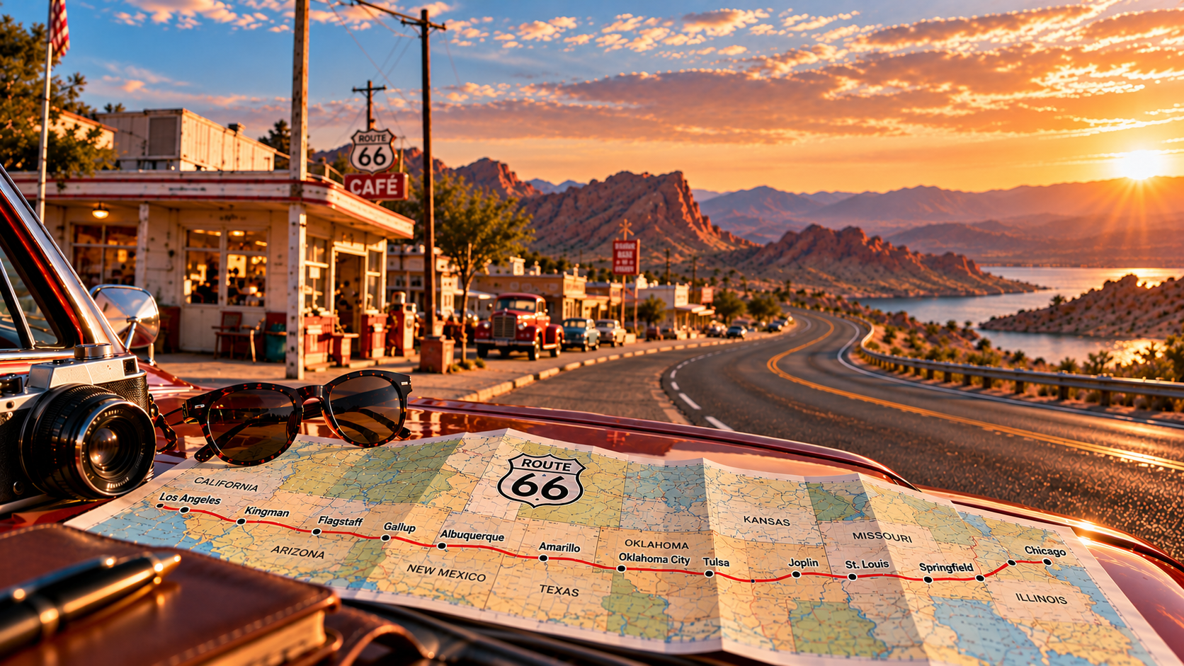
Traveling Route 66 today means piecing together historic alignments, local roads, and occasional stretches of modern highway. The road signs may change, but the journey can still be followed from Chicago to Santa Monica.
Wondering whether Route 66 is still driveable today? Start with our guide, Can You Still Drive Route 66?, to understand what remains of the historic highway before planning your journey.
Here is what the journey looks like today.
Route 66 in Illinois: Chicago to the Mississippi River
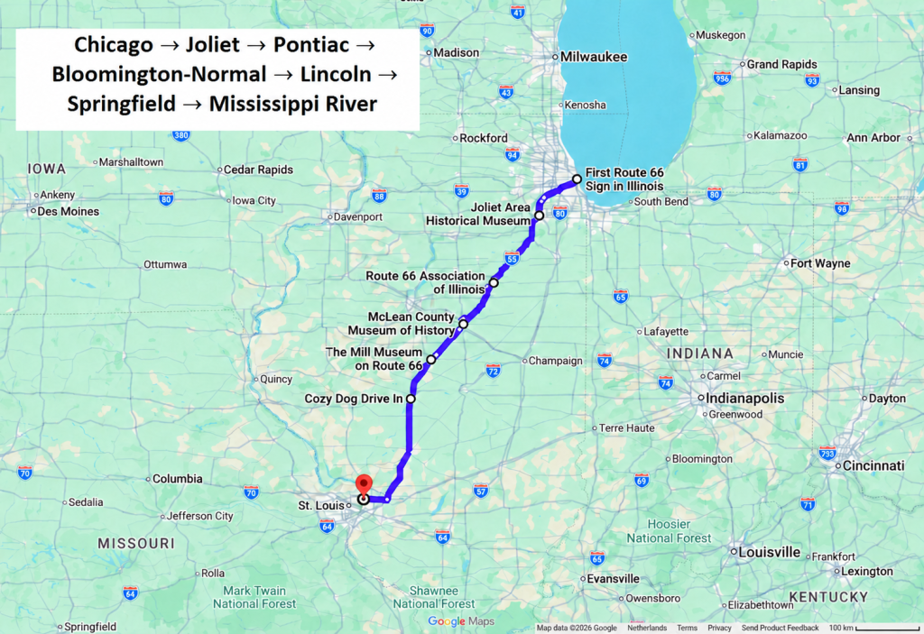
Chicago → Joliet → Pontiac → Bloomington-Normal → Lincoln → Springfield → Mississippi River
Route 66 begins in the middle of modern Chicago, surrounded by tall buildings, traffic, pedestrians, and the noise of the city.
After the photograph beneath the Begin Route 66 sign, the road heads south. Gradually, Chicago falls away and the journey begins to feel like the America travelers imagine when they hear the words “Route 66.”
The highway leads through Joliet, Pontiac, Bloomington-Normal, Lincoln, and Springfield. Murals, restored gas stations, drive-in restaurants, roadside giants, and old theaters begin to appear.
In Pontiac, the Illinois Route 66 Hall of Fame and Museum introduces the people and businesses that kept the road alive. In Normal, Sprague’s Super Service preserves an era when one building could contain a gas station, café, garage, and the owner’s home.
Near Springfield, a surviving brick section shows how different early Route 66 could look from the smooth asphalt of a modern highway. It feels less like a road preserved for tourists and more like something unexpectedly left behind by another century.
Illinois is where the idea of Route 66 becomes clear.
This road was not designed to keep travelers separate from local life. It brought them directly into it.
Route 66 in Missouri: Historic Towns, Bridges, and the Ozarks
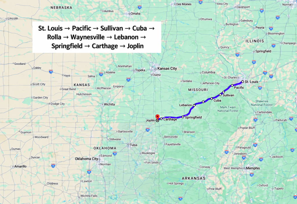
St. Louis → Pacific → Sullivan → Cuba → Rolla → Waynesville → Lebanon → Springfield → Carthage → Joplin
Route 66 crosses the Mississippi River and enters Missouri, where the flat Midwestern landscape begins to change.
The road curves through the Ozarks, passes limestone hills, and repeatedly meets I-44. At some points, the old highway runs beside the Interstate. At others, it disappears into towns the newer road avoids.
Near St. Louis, the Old Chain of Rocks Bridge once carried Route 66 across the Mississippi. Its most unusual feature is a sharp turn in the middle, an unexpected angle on a bridge stretching across such a wide river.
Farther west, Cuba uses large murals to tell stories from local history. Waynesville preserves the Old Stagecoach Stop and the Devil’s Elbow Bridge. In Lebanon, the glowing sign of the Munger Moss Motel recalls the era when a clean room, a television, and a swimming pool were enough to make a roadside motel famous.
Missouri contains several historic alignments, so this is one of the states where a dedicated map becomes important. Choosing the fastest road will repeatedly place you on I-44. Choosing Route 66 will take you through the communities the Interstate left behind.
The Missouri Division of Tourism provides a guide and interactive map covering the state’s 317-mile corridor.
Route 66 in Kansas: 13 Miles of History and Cars Movie Inspiration
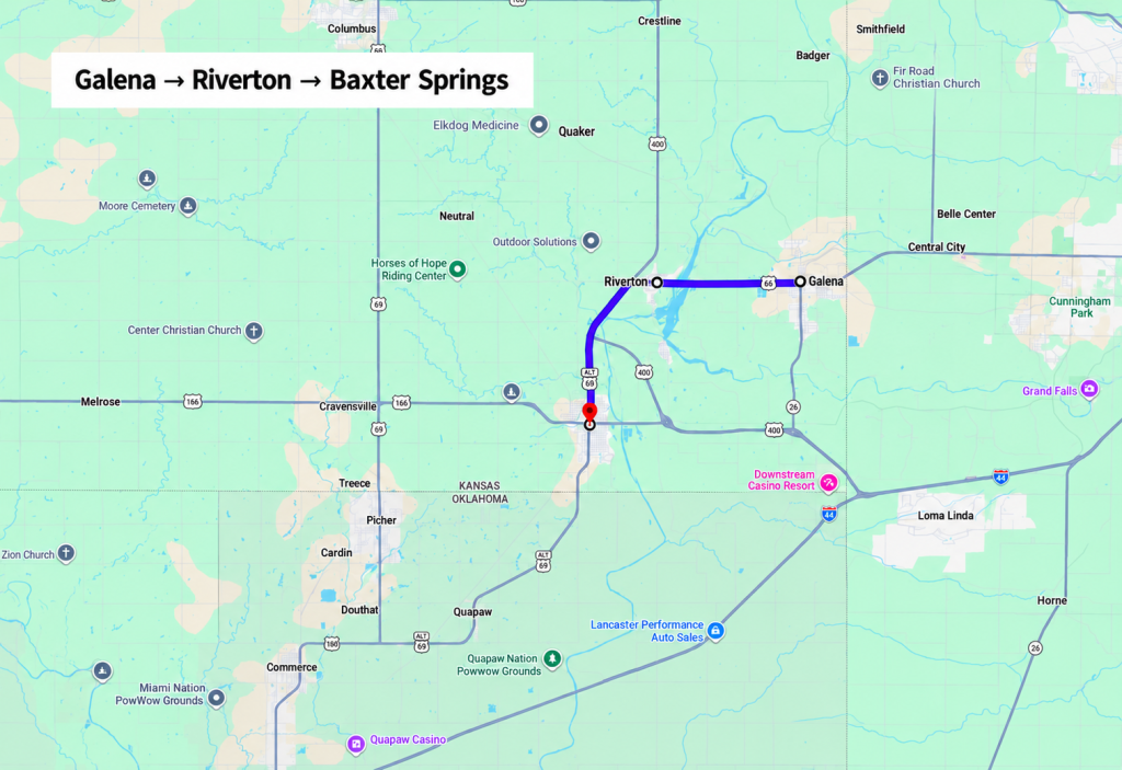
Galena → Riverton → Baxter Springs
Kansas has only about 13 miles of Route 66 and it would be easy to cross the state quickly.
But only a novice would make that mistake.
In Galena, a former Kan-O-Tex gas station from 1934 has become Cars on the Route. Parked outside is a rusty tow truck with crooked teeth and cartoon eyes. His name is Tow Tater.
When members of the Pixar team traveled Route 66 while researching Cars, they visited the old station and saw the truck. Tow Tater became one of the real-life inspirations behind Mater.
Today, visitors can photograph him along with a fire engine and other restored vehicles beside the gas station.
The route then passes through Riverton, crosses the historic Rainbow Bridge, and continues toward Baxter Springs.
Kansas offers the shortest drive of the journey, but one of its clearest connections between the real Route 66 and the imaginary world of Radiator Springs.
Route 66 in Oklahoma: Historic Highways and Roadside Attractions
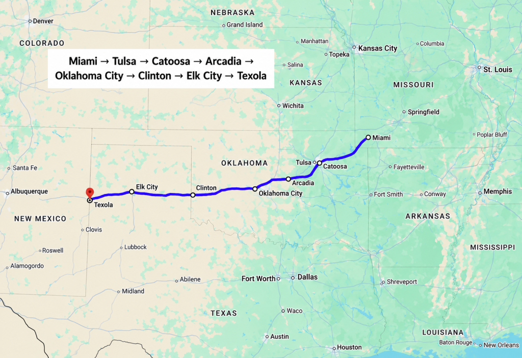
Miami → Tulsa → Catoosa → Arcadia → Oklahoma City → Clinton → Elk City → Texola
Oklahoma contains more than 400 miles of drivable Route 66, making it one of the longest and most complete sections of the journey.
It is also central to the highway’s creation.
Tulsa businessman Cyrus Avery helped develop and promote the route and argued successfully for the number 66. He became known as the Father of Route 66.
Across Oklahoma, travelers encounter long sections of old pavement, historic bridges, museums, filling stations, and towns where the road remains part of everyday life.
Then there are the roadside attractions.
In Catoosa, an enormous blue whale smiles beside a pond.
Zoologist Hugh Davis originally built it as a place where his grandchildren could play and swim. The project grew until the whale stood 20 feet tall and stretched 80 feet from head to tail. Davis and a friend spent two years welding the frame and covering it with cement mixed in five-gallon buckets.
Visitors can still walk inside the whale and climb into a small compartment hidden in its head.
Near Arcadia, another giant object rises beside the road. POPS is marked by a 66-foot soda bottle weighing four tons. After sunset, LED lights make it glow in changing colors. Inside, shelves hold more than 600 varieties of soda, from familiar colas to flavors travelers may never have considered drinking before.
There is also a diner and a gas station, so both the passengers and the car can refuel before returning to the road.
The Blue Whale and the giant bottle may seem absurd, but that is the point.
Route 66 businesses learned that travelers stopped for things they could not see anywhere else.
Route 66 in Texas: Cadillac Ranch, Amarillo, and the Midpoint
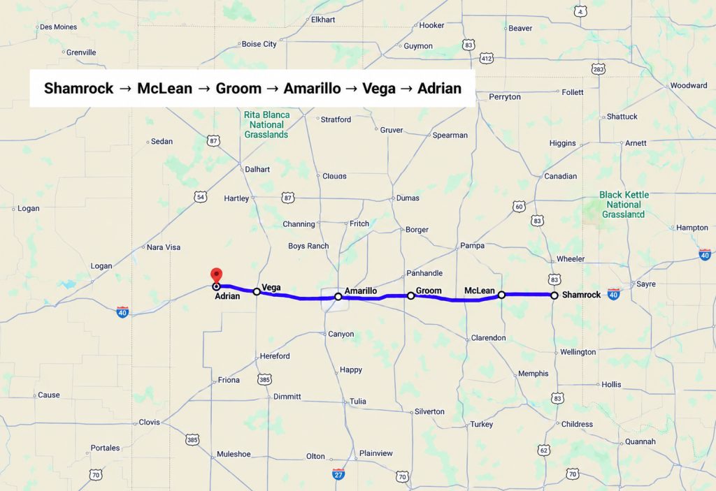
Shamrock → McLean → Groom → Amarillo → Vega → Adrian
Route 66 crosses 177 miles of the Texas Panhandle.
The landscape opens. Towns become farther apart. The old road repeatedly appears beside I-40, sometimes as a frontage road and sometimes as a separate section leading back toward a main street.
In Shamrock, the U-Drop Inn rises unexpectedly from the flat landscape.
Built in 1936, the former gas station and café combines towers, curves, green tiles, and Art Deco details. At night, its restored neon makes the building look almost unreal.
It later inspired Ramone’s Body Shop in Cars.
Continue west and another strange silhouette appears beside the highway near Amarillo.
At Cadillac Ranch, ten Cadillacs are buried nose-first in a field. Their bodies are covered with layers of spray paint left by visitors. The installation constantly changes as new colors, names, and designs cover the old ones.
Then comes Adrian. Beside the MidPoint Cafe, a sign points in two directions:
Chicago: 1,139 miles
Los Angeles: 1,139 miles
This is the traditional midpoint of Route 66.
For westbound travelers, it marks a quiet but meaningful shift. Chicago is now behind you by exactly the same distance that Los Angeles lies ahead. From this point, the Pacific is closer than the beginning.
Route 66 in New Mexico: Historic Alignments and Classic Motels
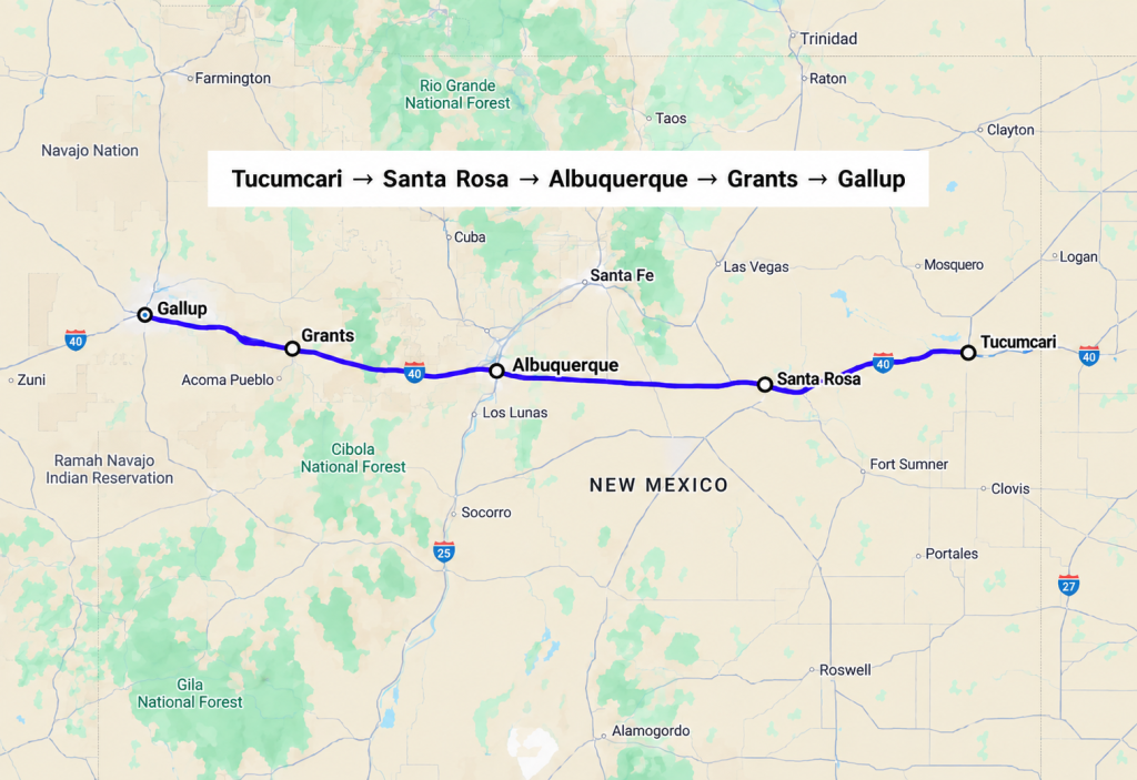
Tucumcari → Santa Rosa → Albuquerque → Grants → Gallup
Route 66 does not offer only one path across New Mexico.
The earlier alignment made a long loop through Santa Fe. In 1937, the road was redirected along a faster east-west route through Albuquerque. Travelers now have to choose which version of the highway they want to follow or allow enough time to experience parts of both.
The direct route enters Tucumcari, one of the best places to imagine Route 66 at the height of the motel era.
After dark, old neon signs glow along the highway. They once competed for the attention of tired motorists, promising vacancies, air-cooled rooms, televisions, and comfortable beds. Some motels are gone. Some remain open. Others survive only through their signs and façades.
The route continues through Santa Rosa and Albuquerque before following the I-40 corridor toward Grants and Gallup.
New Mexico is where Route 66 begins to feel unmistakably Southwestern. The distances grow longer, the sky seems larger, and roadside architecture mixes Pueblo-inspired design with neon, stucco, and mid-century Americana.
It is also a state where selecting the correct alignment matters. The official New Mexico Route 66 guide helps travelers choose between the surviving roads.
Route 66 in Arizona: Historic Towns, Scenic Drives, and Cars Landmarks
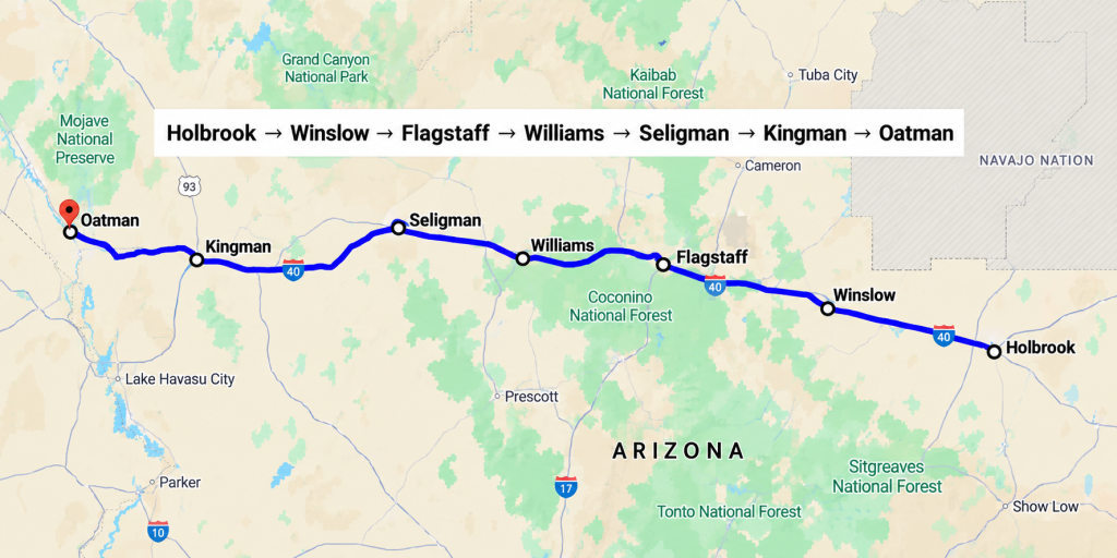
Holbrook → Winslow → Flagstaff → Williams → Seligman → Kingman → Oatman
Arizona contains some of the most atmospheric sections of Route 66.
The road passes through desert, red-rock country, high-elevation pine forest, railroad towns, and former mining communities. It also contains places whose real histories seem remarkably close to the story of Cars.
In Holbrook, travelers can spend the night in a concrete teepee.
The Wigwam Motel opened in 1950. Its individual rooms are shaped like teepees, while vintage automobiles parked outside complete the feeling of arriving on a preserved film set.
Then Route 66 reaches Winslow.
The town became internationally famous because of the Eagles song Take It Easy. Today, a flatbed Ford stands permanently beside Standin’ on the Corner Park. A large mural, bronze figures, and the parked truck turn a song lyric into one of the road’s most recognizable photo stops.
Winslow is also home to La Posada, built in 1929. It was the last great railroad hotel developed by the Fred Harvey Company and one of architect Mary Colter’s Southwestern masterpieces.
From the desert, the road climbs toward Flagstaff.
At almost 7,000 feet, Route 66 enters ponderosa pine forest. The air cools, mountains appear, and winter travelers may encounter deep snow rather than desert heat.
A nearly block-long mural on the side of the Lumberyard Brewing Company depicts classic cars, local Route 66 landmarks, and scenes from Flagstaff’s history. It has become one of the city’s most recognizable selfie backgrounds.
West of Flagstaff lies Williams, the last Route 66 community bypassed by the Interstate. I-40 finally redirected traffic around the town in 1984, shortly before the highway was decommissioned.
Then comes Seligman.
Old cars with painted eyes stand beside colorful businesses. Signs compete for attention. Mannequins, jokes, vintage gas pumps, and humorous displays cover the main street. The desert landscape beyond the buildings looks uncannily like the world surrounding Radiator Springs.
But Seligman’s connection with Cars is deeper than mere appearance.
When I-40 bypassed the town in 1978, businesses that depended on highway traffic began losing customers. Cars no longer passed their doors. Travelers no longer needed their gas stations, motels, cafés, or stores.
Angel Delgadillo, a local barber and business owner, helped organize a movement to preserve the old highway. In 1987, Arizona recognized the Seligman-to-Kingman section as Historic Route 66. The campaign helped renew interest in the road across the country.
Seligman lived through the same crisis at the heart of Cars: a faster highway opened, the traffic disappeared, and a once-busy town was suddenly left behind.
Unlike many communities, Seligman found a way to bring travelers back.
From Seligman, Route 66 continues through Kingman and climbs into the Black Mountains. The road becomes narrow and winding before reaching Oatman, a former mining town where wild burros walk along the main street. They are descendants of the animals once used in local mines. Today, they wander between visitors, shops, and parked vehicles as if they own the town.
Oatman also stages Wild West gunfight reenactments directly on Route 66. Inside the historic Oatman Hotel, visitors can see a room associated with Clark Gable and Carole Lombard. The saloon’s walls and ceiling are covered with dollar bills left by generations of guests.
The drive between Kingman and Oatman deserves time. It is not a section to rush. The curves are sharp, the road is narrow, and the views across the mountains are part of the experience.
Route 66 in California: Mojave Desert to Santa Monica Pier
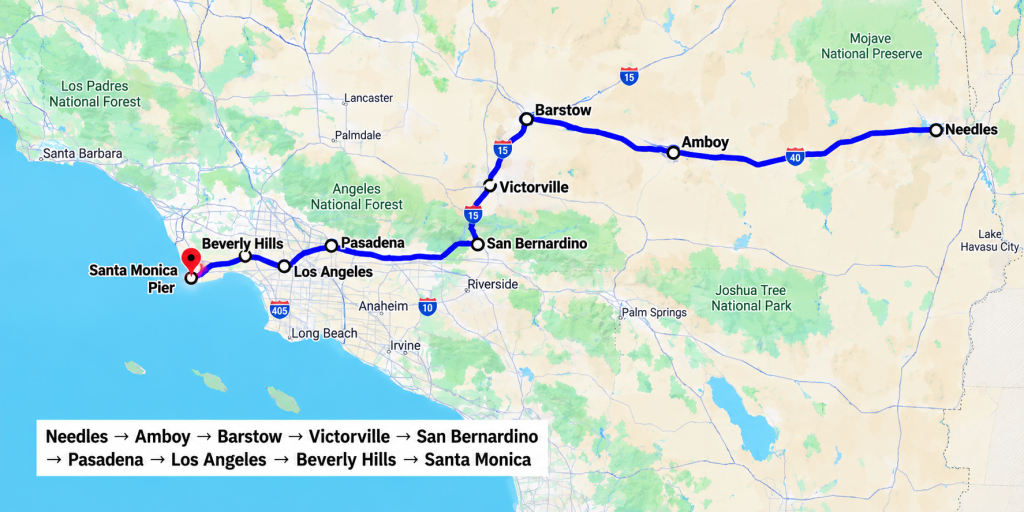
Needles → Amboy → Barstow → Victorville → San Bernardino → Pasadena → Los Angeles → Beverly Hills → Santa Monica
Route 66 enters California near Needles and crosses the Mojave Desert. This is one of the most remote parts of the journey. Settlements shown on the map may have few or no services. Gas stations can be far apart. In summer, temperatures can become dangerous.
Then, in the middle of the desert, the Roy’s sign appears.
Roy’s began as a gas station in Amboy in 1938. A café, motel, and repair shop followed. In 1959, a 50-foot neon sign was installed, large enough to attract motorists from miles away.
Amboy grew around the traffic. Then I-40 opened and the traffic moved.
The town’s businesses closed, its population collapsed, and Roy’s became one of the most haunting symbols of what the Interstate did to Route 66 communities.
The gas station now sells fuel and basic supplies again, but the empty motel and enormous sign still stand against the desert. It is beautiful, photogenic, and slightly unsettling, especially when you know why the town became so quiet.
The road continues toward Barstow and Victorville.
Inside the California Route 66 Museum in Victorville are vintage gas pumps, road signs, memorabilia, and a recreated diner. Its photo displays include a Volkswagen Love Bug and a staged road-trip scene.
From the desert, the route descends into the growing urban landscape of Southern California. San Bernardino contains another Wigwam Motel, built in 1949. Its concrete “teepees” stand approximately 32 feet high around a retro kidney-shaped swimming pool.
Unlike many preserved Route 66 landmarks, this one still serves its original purpose. You can spend the night here.
San Bernardino also has a surprising place in American food history.
A museum stands at the site of the first McDonald’s restaurant, opened by Richard and Maurice McDonald in 1940. Nearby, Mitla Cafe has served Mexican food since 1937. Its tacos are associated with the early inspiration behind the business that eventually became Taco Bell.
The final section passes through Pasadena and Los Angeles. Open desert is replaced by traffic lights, neighborhoods, stores, freeways, and the enormous urban grid of Southern California. Route 66 continues through Beverly Hills and toward Santa Monica.
Then, after more than 2,400 miles, the road reaches the ocean.
The End of the Trail sign stands on Santa Monica Pier. Behind it are the amusement park rides and restaurants of the pier. Ahead is the Pacific.
There is nowhere farther west for the road to go.
How to Navigate Route 66 Today Using Dedicated Historic Maps
In 2026, Rand McNally published The Official Route 66 Centennial Map, a printed foldout map designated an Official Route 66 Centennial Project by the Route 66 Centennial Commission. It shows sections of the original historic alignments alongside the modern roads that can still be driven today.
Use it together with the National Park Service Route 66 travel itinerary and the tourism maps and Route 66 guides published by individual states. The official Route 66 Centennial website provides additional information about centennial projects and events.
Is Route 66 Still Worth Driving in 2026?
Yes. But not as a way to cross the United States. It is worth driving precisely because it is slower. The Interstate shows you the distance between cities.
Route 66 shows you what happened to the places in between.
It passes through communities that grew around the automobile, businesses that survived after the traffic disappeared, and towns that refused to be erased from the map.
Its story includes camels, migration, war, family vacations, neon signs, giant roadside animals, music, television, animation, economic decline, and preservation.
In 2026, Route 66 celebrates its 100th anniversary.
A century after the highway was created, you can still stand beneath the starting sign in Chicago, photograph the tow truck that helped inspire Mater, drink soda beneath a 66-foot bottle, sleep in a concrete teepee, watch wild burros walk through a mining town, cross the Mojave, and finish on Santa Monica Pier.
The highway number disappeared from official maps. The journey never did.
And even if you are not crossing all eight states, you can still experience its final moment. Our Las Vegas to Los Angeles itinerary reaches Route 66 at Santa Monica Pier, where the Mother Road’s journey across America finally meets the Pacific.
Curious to explore the world beyond the ordinary? 🌍 Download the TravUp app and discover more, experience deeper, and travel with ease!
App Store: https://apps.apple.com/us/app/travup/id6758667212
Google Play: https://play.google.com/store/apps/details?id=com.travelup.mobileapp